Resilience Enhancement with AW3D : Global High-resolution 3D Map
NTT DATA Corporation
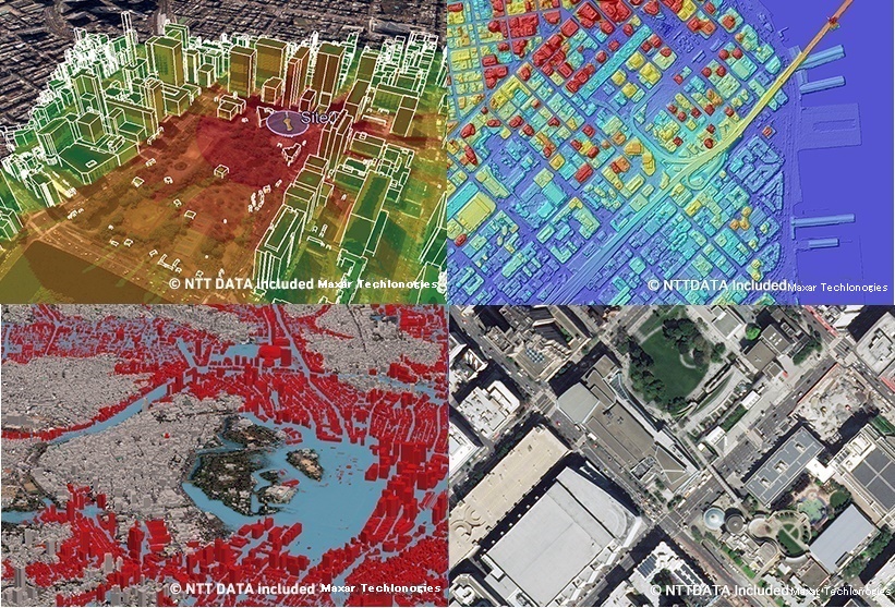
Top Left:Communication infrastructure development, Bottom Left:Disaster Mitigation, Top Right:AW3D Enhanced(San Francisco), Bottom Right:Ortho Imagery(San Francisco)
Advanced Image Processing Algorithm x High-performance Data Processing System
Outline
AW3D®, provided by NTT DATA in collaboration with the Remote Sensing Technology Center of Japan, is based on the world’s highest-performance satellite imaging data and image processing technology. In effect, it is a “Global High-resolution 3D Map”.
The speed and newness of the 3D data, which is provided in the form of images and extracted information with 0.5-meter maximum resolution, makes AW3D® a viable alternative to aerial surveys and field surveys. Using AI to analyze images makes it possible to extract information on buildings and other geological features and monitor changes over time.
Since its launch in 2014, AW3D® has been used in more than 2,000 projects in over 130 countries around the world. Its usages include urban development, agriculture, airports and ports, electricity, roads and railways, disaster prevention and disaster response, and forest and green management. For example, it is useful for simulating the flow of wind from surrounding landforms, the amount of rainwater flowing out of mountains during heavy rain, and landslides during the construction of wind power plants.
In collaboration with the Japan Aerospace Exploration Agency (JAXA), NTT Data is undertaking research to improve the accuracy of 3D maps by utilizing new technologies being developed by JAXA. After the realization, we plan to conduct research on data analysis technology with even higher accuracy reflecting the results of our research, as well as research on the application of the urban digital twin to smart cities and the understanding of forest resources to the environmental field.
Description
■Our Challenge
Enhancing Climate Resilience through the Creation of New Services Based on the High-Precision 3D Maps Developed by NTT Data and JAXA
■Background and Challenges
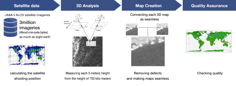
In recent years, natural disasters such as floods and landslides have occurred almost every year due to abnormal weather caused by climate change around the world. High-precision 3D maps are needed to more accurately identify and identify areas at risk from disasters. In addition, the use of 3D maps in cities, construction, transportation, and other industries is increasing, and there is a need for more accurate maps in order to further improve operational efficiency and add value. To date, NTT Data has responded to these demands by developing the Global Digital 3D Mapping Service "AW3D" using satellite images from JAXA and other organizations. However, since normal satellite images cannot directly observe the ground surface covered with trees and vegetation, there has been a problem in observing the ground surface necessary for hazard maps of forest areas.
To address these issues, NTT Data and JAXA believe that JAXA's research on "spacecraft laser altimeter" technology, which can accurately measure ground level and the height structure of forests, is effective, and are conducting joint research on technology to improve the accuracy of 3D maps, which can be applied to hazard maps in areas around the world, including forests, and can be used in a variety of fields. In this joint research, JAXA will research the technology to accurately measure the height of the ground surface using the data acquired by the laser altimeter, and NTT Data will research the technology to accurately create the height model of the ground surface using the height data measured by the laser altimeter and the height model of the ground surface including the tree height created from satellite images. Using the results of this research, we aim to achieve high accuracy of hazard maps and other information for the world in digital 3D mapping services.
■Action
NTT DATA will conduct research and development on technology to accurately create a ground height model using high-precision height data obtained by JAXA's technology to accurately measure the ground height using a laser altimeter and a ground height model including tree heights created from satellite images.
NTT DATA will use the results of this research to improve the accuracy of its 3D mapping service, including hazard maps. Specifically, since aircraft and other instruments have been used to obtain highly accurate data, hazard map creation has been limited to major rivers in developed countries. However, we expect to use highly accurate data observed over a wide range from satellites and expand it to areas around the world, including developing countries.
■Future development
After collaborating with JAXA to improve the accuracy of 3D maps, NTT Data plans to continue research on data analysis technologies that reflect the results of its research, as well as research on the application of urban digital twin technology to smart cities and the environmental field of forest resources.
In addition to using hazard maps prior to a disaster, we are also testing the use of other technologies in combination with other technologies during a disaster.
We will continue to strive to create new services that strengthen resilience.
Partner(s)
・Remote Sensing Technology Center of Japan: RESTEC
・The Japan Aerospace Exploration Agency: JAXA
Supplementary information
AW3D® https://www.aw3d.jp/en/
Other Innovation Challenges
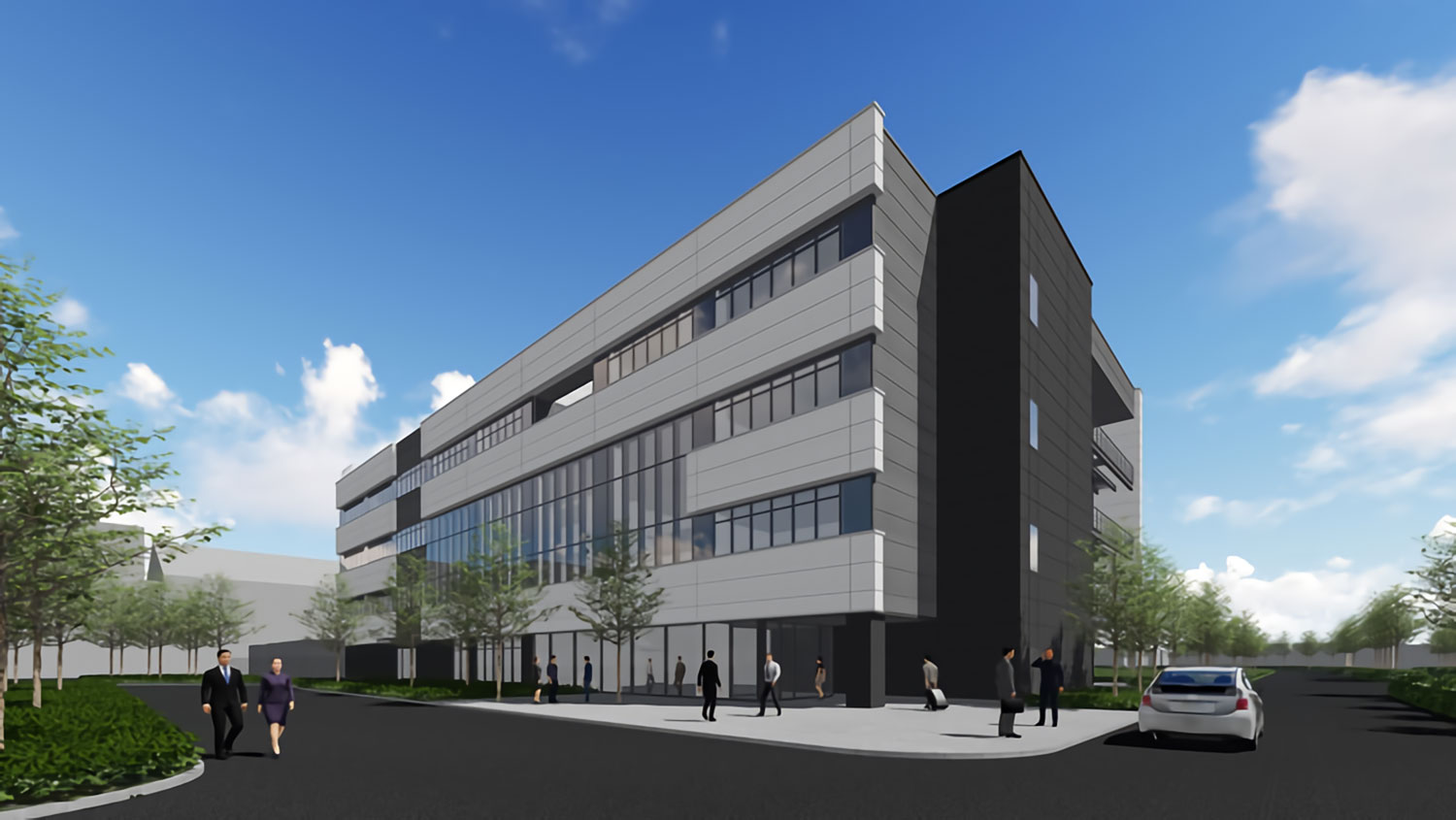
“Mitaka Data Center EAST” that has One of the Largest and Most Advanced Features in Japan while Achieving Excellent Environmental performance
NTT DATA Corporation
Similar Innovation Challenges
Accelarating the penetration of renewable energy resources with “Open Energy System”
Sony Group Corporation

Achieving net-zero carbon emissions from plant factories using full artificial lighting
Taikisha Ltd.
Advanced technology for buildings providing energy-saving and comfortable indoor environment (under Net Zero Energy condition)
Mitsubishi Electric Corporation
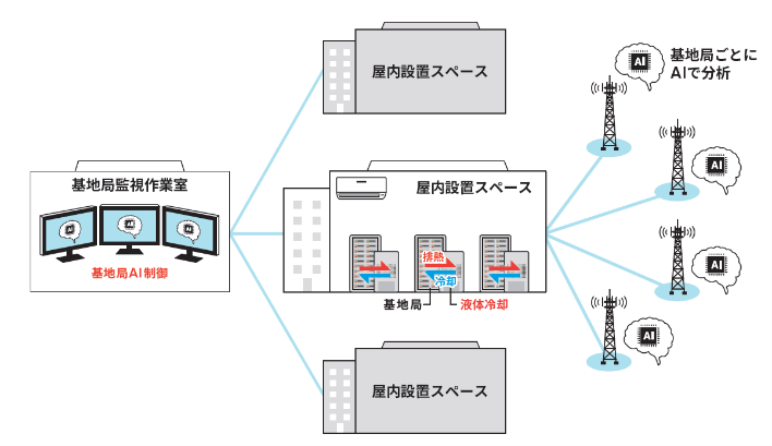
AI control reduces base station power consumption by up to 50%
KDDI CORPORATION